 Written by
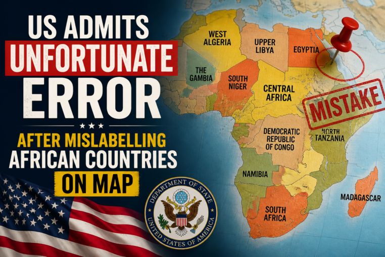
 The United States government has admitted an unfortunate error after mislabelling African countries on an official map, a blunder that sparked widespread criticism and ridicule across the continent and beyond. The mistake, which appeared in a State Department publication, incorrectly placed the names of several nations over the wrong territories, effectively redrawing the borders of Africa in a way that erased the identity of entire countries. While the administration quickly acknowledged the fault and issued a formal apology, the incident has reignited a long-standing debate about the persistent, systemic lack of geographic literacy within American institutions and the broader Western world.
The error was first noticed by eagle-eyed diplomats and social media users who spotted the map attached to a routine press release regarding international aid programs. Upon closer inspection, it became clear that the cartographic data was severely flawed. For instance, the label for Ghana was positioned squarely over the borders of Togo, while the name “Benin” was stretched across the landmass of Nigeria. In another glaring mix-up, the Republic of the Congo and the Democratic Republic of the Congo were not only conflated but their respective territories were assigned to neighboring Angola and Gabon. The map also managed to completely omit the island nation of Cape Verde and misplace the location of Somalia, placing it further inland and erasing its entire coastline.
The Importance of Accurate African Cartography
This incident highlights a critical issue: the importance of accurate African cartography in international relations. A map is not merely a visual aid; it is a statement of recognition and respect. When a global superpower like the United States publishes a map that jumbles the sovereign territories of over a dozen nations, it sends a subconscious message that these borders are unimportant or interchangeable. For African nations, many of whom fought hard for their independence and maintain strict border integrity inherited from the post-colonial era, such an error is deeply offensive. It undermines the very concept of national sovereignty and suggests a level of disregard that contradicts the diplomatic overtures of partnership and mutual respect that the US often professes.
The State Department’s subsequent apology, which described the map as an “unfortunate error” and a “production mistake,” did little to quell the anger. Critics argue that this was not a simple typo but a symptom of a deeper institutional failure. The fact that a map of an entire continent could pass through multiple layers of editing, graphic design, and approval without a single person noticing that the countries were in the wrong locations points to a severe lack of internal oversight. It suggests that the individuals responsible for the publication possess a dangerously limited knowledge of African geography, a deficiency that could have practical consequences in policy-making and crisis response.
How the Mislabelling Incident Affects US-Africa Relations
The mislabelling incident affects US-Africa relations on multiple levels. On the surface, it is a diplomatic embarrassment that forces American ambassadors to spend valuable time issuing damage control statements. However, the deeper impact is one of trust. African leaders and citizens often view such errors as evidence of a paternalistic attitude that has historically characterized Western engagement with the continent. When the US fails to accurately depict the physical reality of a partner nation, it raises questions about how well it understands the political, economic, and cultural nuances of that nation. This incident provides ammunition for those who argue that the US views Africa as a monolithic bloc rather than a diverse collection of distinct countries with unique histories and challenges.
Furthermore, the timing of the error could not have been worse. The Biden administration has made significant strides in recent years to strengthen ties with Africa, hosting the US-Africa Leaders Summit and pledging billions of dollars in investment. This map threatens to undo some of that goodwill, reinforcing a narrative that the US commitment to the continent is superficial. It is difficult to take a partner seriously when they cannot be bothered to learn the correct location of your capital city or your borders. The apology, while accepted formally, has left a bitter taste, with many commentators noting that the US would likely never have made such a glaring error on a map of Europe.
Learning From the US Map Mistake
There is a valuable lesson to be learned from the US map mistake, not just for the State Department but for media outlets, educational institutions, and corporations worldwide. The first step is to acknowledge that geographic literacy is a professional necessity, not an optional skill. Organizations that operate on a global scale must invest in rigorous fact-checking procedures that include geographic verification. It is no longer acceptable to rely on outdated clip-art or generic map templates that have not been updated for decades. The second lesson is the need for diversity in the workforce. Had the map been reviewed by a team that included individuals of African descent or experts specializing in African studies, the error would likely have been caught immediately. A homogeneous team lacks the diverse perspectives required to catch such cultural and geographic insensitivities.
In conclusion, while the United States has admitted the unfortunate error after mislabelling African countries on the map, the incident serves as a stark reminder that respect must be demonstrated through knowledge. An apology is a necessary first step, but it is not a substitute for substantive change. The US must now prove, through concrete actions and improved internal standards, that it values its relationship with Africa enough to get the basics right. Until then, this map will remain a symbol of a broader problem—a lingering colonial mindset that continues to view Africa through a distorted lens. The hope is that this embarrassment will serve as a catalyst for reform, ensuring that such a careless mistake never happens again.